For forward-thinking developers eyeing the rapid growth corridors of Victoria, Melton Master-Plan Drone Surveying for Developers offers an indispensable tool for precision, efficiency, and insight. As Melton continues its remarkable transformation from a vibrant regional hub to a significant urban centre, the demands for accurate and timely site data have never been higher. At SkyShots, we understand the unique challenges and opportunities this expansion presents, providing cutting-edge aerial solutions that lay the groundwork for successful master-plan execution.
Revolutionising Development Planning in Melton
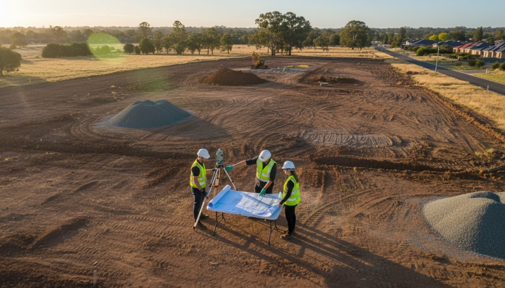
Melton’s landscape, where country charm meets urban expansion, requires a meticulous approach to development. Traditional surveying methods, while foundational, can be time-consuming and costly, especially across large, complex sites characteristic of master-plan projects. Drone technology from SkyShots fundamentally shifts this paradigm, delivering high-resolution imagery and precise topographical data with unparalleled speed and safety.
The SkyShots Advantage in Melton Master-Plan Mapping
Our drone surveying services go beyond simple photography. We capture detailed orthomosaic maps, digital elevation models (DEMs), and 3D point clouds that are critical for every stage of your development. Imagine having a comprehensive, up-to-date visual and spatial understanding of your site near the Western Freeway or along the new housing estates bordering Toolern Creek, all accessible at your fingertips. This data is crucial for:
- Accurate Site Analysis: Identifying contours, drainage patterns, and existing infrastructure with pinpoint accuracy.
- Volume Calculations: Precisely measuring earthworks and material stockpiles, saving significant costs.
- Progress Monitoring: Regularly tracking construction progress against master plans, ensuring projects stay on schedule.
- Stakeholder Communication: Presenting clear, visual data to investors, council, and the community.
By leveraging the latest drone technology, we minimise on-site disruption and reduce the risks associated with ground-based surveying. Our skilled operators are CASA-certified and deeply familiar with the regulatory landscape, ensuring all operations are conducted safely and legally.
Precision Data for Informed Decisions
Every successful master plan hinges on informed decision-making. With SkyShots, you receive actionable intelligence derived from our high-precision aerial surveys. This allows developers to optimise land use, plan infrastructure more effectively, and mitigate potential issues before they become costly problems. From conceptual design through to construction completion, our data empowers you to make smarter choices for your Melton projects.
We work closely with architects, urban planners, and construction managers to tailor our services to your specific needs. Whether it’s mapping a greenfield site for a new residential community or overseeing the expansion of an industrial precinct, our aerial insights provide the clarity you need. Explore our full range of aerial photography and surveying services to see how we can assist your next venture.
Partnering for Melton’s Future
Melton is a community on the rise, and its future master-planned communities require visionary development backed by solid data. SkyShots is proud to be a local partner, contributing to the smart growth and infrastructure development that benefits residents and businesses alike. Our commitment to accuracy, efficiency, and professional service makes us the go-to choice for aerial surveying in the region.
For more information on local planning and development initiatives in Melton, you can visit the official Melton City Council website. Understanding the local context is key, and our drones provide the perfect vantage point.
Don’t leave your master plan to chance. Elevate your development projects in Melton with the unparalleled precision of SkyShots’ drone surveying expertise. Ready to discuss your project’s aerial mapping needs? Contact SkyShots today for a consultation and discover how our advanced drone solutions can provide your competitive edge.
Leave a Reply