Officer, a vibrant and rapidly expanding suburb in Melbourne’s southeast, is a hub of exciting property development. From sprawling new residential estates to burgeoning commercial centres, the landscape is constantly evolving. In this dynamic environment, making your project truly stand out requires more than just traditional photography. This is where SkyShots comes in. We understand the unique demands of this market and are here to help you elevate Officer property development with professional aerial photos, offering unparalleled visual insights and marketing advantages.
The Officer Advantage: Why Aerials Matter for Property
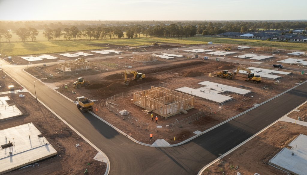
Officer’s growth trajectory is undeniable. With new communities forming and infrastructure expanding, developers face the challenge of showcasing their vision in a competitive market. Aerial photography provides a bird’s-eye perspective that simply cannot be achieved from the ground. It allows potential buyers, investors, and stakeholders to grasp the scale, context, and potential of your development like never before. Imagine clearly illustrating proximity to future parks, schools, or the Princes Freeway – all vital for an Officer family or business.
Beyond the Ground: Visualising Progress and Potential
From initial land surveys to ongoing construction updates and final marketing imagery, aerial photography is invaluable at every stage of a property development lifecycle. Our high-resolution drone imagery helps you monitor site progress, identify potential issues early, and communicate effectively with investors. For marketing, a stunning aerial shot can capture the essence of a new estate, highlighting its connection to the wider Officer community and its surrounding natural beauty, such as the distant glimpses of the Dandenong Ranges or local green wedges.
Our Comprehensive Aerial Solutions for Officer
At SkyShots, we specialise in delivering tailored aerial photography and videography services designed to meet the specific needs of Officer’s property sector. Whether you require detailed topographical surveys, engaging progress reports, or captivating promotional content, our state-of-the-art drones and experienced pilots ensure exceptional results. We provide:
- Land & Site Surveys: Accurate, up-to-date aerial mapping for planning and assessment.
- Construction Progress Monitoring: Regular, consistent visual updates to track your build.
- Marketing & Sales Photography: Breathtaking images that attract buyers and investors.
- Environmental Impact Assessments: Visual documentation for regulatory compliance.
Discover our full range of commercial services at skyshots.com.au/services/commercial.
Capturing Officer’s Unique Character from Above
Officer is more than just a developing suburb; it’s a community with its own distinct charm. Our team understands the local landscape, from the sprawling greenfield sites transforming into vibrant neighbourhoods to the established areas retaining their rural feel. We pride ourselves on capturing the unique blend of progress and character that defines Officer, ensuring our aerial photographs resonate with your target audience. For more information on local development plans and community initiatives, you might visit the Cardinia Shire Council website.
Partnering with SkyShots: Your Trusted Aerial Experts
When you choose SkyShots, you’re partnering with an accredited, insured, and highly experienced team dedicated to safety, professionalism, and stunning visual outcomes. We use advanced drone technology to capture crisp, clear images and cinematic video, transforming your development projects into compelling visual stories. Our expertise ensures that every shot not only showcases your project but also enhances your brand’s reputation for quality and innovation.
Explore our portfolio to see how we’ve helped other clients visually transform their projects: skyshots.com.au/portfolio/property.
Don’t let your Officer property development blend into the background. Let SkyShots provide the aerial perspective that highlights its true potential and captivates your audience. Contact us today to discuss how our professional drone photography can make your next project truly soar. For local area information on Officer, check out resources like Visit Victoria’s Officer page.
Leave a Reply