Keysborough, a vibrant suburb in Melbourne’s southeast, boasts a surprising wealth of natural beauty, often best appreciated from a vantage point high above. At SkyShots, we specialise in transforming ordinary perspectives into extraordinary revelations. Our expertise in capturing Keysborough Dandenong Creek aerial views allows us to unveil the hidden intricate patterns, lush landscapes, and dynamic waterways that define this unique area.
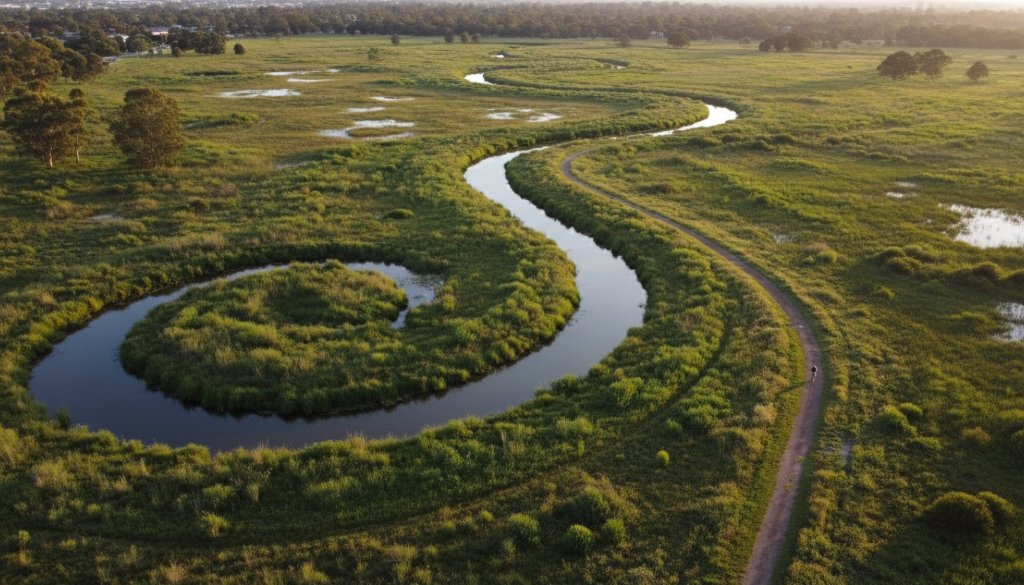
From the ground, the Dandenong Creek trail is a beloved local amenity, winding its way through parks and reserves. But ascend with a drone, and an entirely new narrative unfolds. The creek transforms into a silver ribbon, meandering through a tapestry of green wetlands, ancient gum trees, and meticulously managed parklands. This elevated perspective highlights the creek’s vital role as an ecological corridor, supporting diverse flora and fauna, and offers a profound appreciation for Keysborough’s commitment to preserving its natural heritage.
Unveiling Dandenong Creek’s Aerial Grandeur
Aerial photography of Dandenong Creek in Keysborough isn’t just about pretty pictures; it’s about providing valuable insights. For environmental agencies, these images can monitor waterway health, track vegetation changes, and assess flood plain management. For urban planners, they offer critical data on land use and potential development impact. And for residents, they simply inspire awe, revealing the natural splendour that often goes unnoticed in our daily lives. We capture the intricate details, from the subtle variations in water colour to the canopy of the indigenous trees, painting a comprehensive picture of this natural asset.
Beyond the immediate banks of the Dandenong Creek, our aerial services extend to other significant Keysborough landmarks. Imagine seeing the expansive grounds of the local sporting complexes, the sprawling residential developments, or even the detailed layouts of industrial precincts, all from a breathtaking bird’s-eye view. This perspective offers unparalleled clarity and a holistic understanding of the suburb’s landscape, showcasing the blend of urbanisation and natural pockets that coexist harmoniously.
Our aerial photography services are indispensable for a range of clients. Real estate agents leverage stunning drone footage to showcase properties with their surrounding natural amenities. Businesses utilise our high-resolution imagery for site planning, progress monitoring, or marketing campaigns that truly stand out. Furthermore, local councils and community groups often engage SkyShots to document environmental projects, public spaces, and community events, providing a historical record and promoting local initiatives.
Why Choose SkyShots for Your Keysborough Project?
At SkyShots, we pride ourselves on our deep understanding of local Australian landscapes, combining technical precision with artistic flair. Our CASA-certified pilots are not just operators; they are visual storytellers, skilled in capturing the perfect light and composition that bring Keysborough’s aerial beauty to life. We use state-of-the-art drone technology to ensure crisp, high-resolution imagery and video, delivering results that consistently exceed expectations.
Whether you’re looking to document a construction project, capture the essence of a local event, or simply want to immortalise the natural beauty of your property or local area, SkyShots is your trusted partner. Discover more about our comprehensive aerial photography services and browse our diverse portfolio. For more information on the Dandenong Creek and its trails, you can visit Parks Victoria’s website. For local Keysborough information, refer to the City of Greater Dandenong. Let us elevate your perspective and show you Keysborough as you’ve never seen it before. Contact us today to discuss your vision.
Leave a Reply