In the dynamic landscape of Victoria’s infrastructure development, Bulleen Eastern Freeway drone photography is becoming an indispensable tool for heavy civil and transport projects. From the ongoing North East Link Project transforming the Bulleen area, connecting the M80 Ring Road to the Eastern Freeway, to other vital transport initiatives, capturing the scale and complexity of these endeavours requires precision, insight, and an elevated perspective. SkyShots is proud to be at the forefront, offering specialised aerial imaging services that provide unparalleled clarity and detail for engineers, project managers, and stakeholders alike.
The SkyShots Advantage in Heavy Civil & Transport Infrastructure
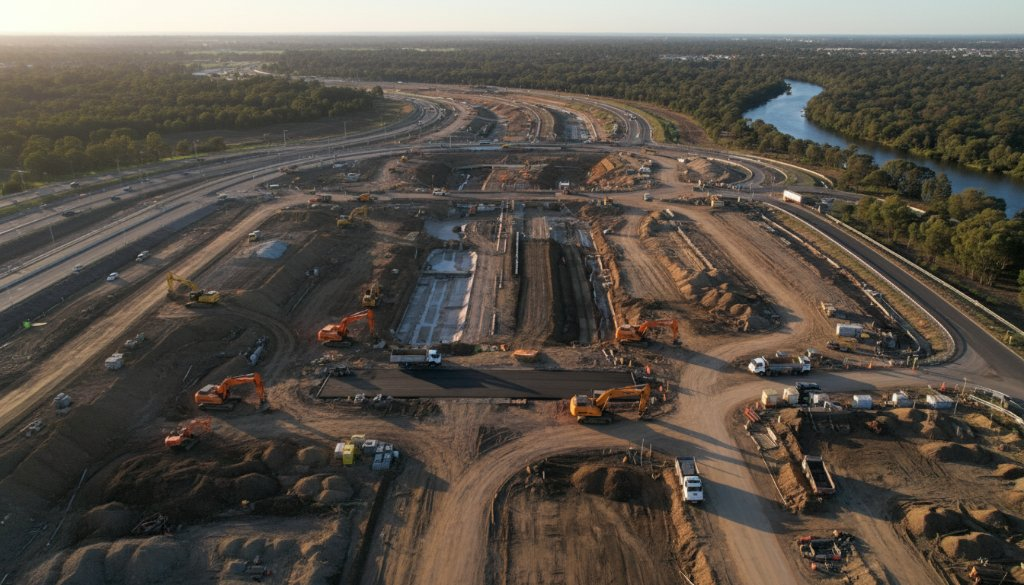
Bulleen Eastern Freeway Drone Photography: An Unmatched Perspective
Working on major projects around Bulleen, such as upgrades to the Eastern Freeway or significant bridge constructions near the Yarra River, demands meticulous planning and execution. Traditional ground-based photography simply cannot convey the full scope of these massive undertakings. That’s where professional drone photography shines. SkyShots provides high-resolution imagery and video, offering a bird’s-eye view that is crucial for:
- Progress Monitoring: Documenting construction phases with incredible accuracy. Regular aerial surveys allow for visual progress reports, identifying potential issues early and ensuring projects stay on schedule. Learn more about our progress monitoring services.
- Site Planning & Analysis: Gaining comprehensive topographical data, assessing site logistics, and planning equipment placement more effectively.
- Safety Inspections: Conducting remote inspections of hard-to-reach areas, reducing risks for personnel and speeding up assessment times. Explore our asset inspection capabilities.
- Stakeholder Communication: Presenting compelling visual narratives to investors, government bodies, and the public, showcasing the project’s impact and progress.
Capturing the Vision: From Planning to Completion
For any heavy civil construction in Bulleen, whether it’s the sweeping new lanes of the Eastern Freeway or intricate bridge works, the ability to see the entire site from above offers a strategic advantage. Imagine documenting the progress of a complex interchange, highlighting the intricate engineering, or showcasing the environmental integration of a new bypass that respects Bulleen’s natural beauty. Our team understands the unique challenges of large-scale infrastructure projects, from adhering to strict safety protocols to operating within busy construction environments.
We’ve worked with numerous clients across Australia, delivering precise and actionable aerial data. Our expertise in navigating the specific requirements of heavy civil and transport projects means we capture exactly what you need, when you need it. We’re not just taking photos; we’re providing vital visual intelligence that supports critical decision-making throughout the project lifecycle. The North East Link Project, for example, is a prime illustration of the kind of monumental effort that benefits immensely from advanced aerial documentation.
Beyond the technical benefits, our photography also helps tell the story of these incredible feats of engineering. Projects in Bulleen are not just concrete and steel; they are about connecting communities, improving transport flow, and shaping the future of this vibrant Melbourne suburb. The visual narrative of progress, innovation, and local development is powerful.
Why Choose SkyShots for Your Bulleen Project?
As a local Australian business, SkyShots brings a deep understanding of the local landscape and regulatory environment. Our certified drone pilots are not just skilled photographers; they are experienced operators who prioritise safety and efficiency on every project. We’re committed to delivering exceptional aerial imagery that exceeds expectations, providing a comprehensive visual record that enhances project management and communication. We understand the specific nuances of working within a community like Bulleen, nestled beside the Yarra River and evolving rapidly.
Ready to elevate your next heavy civil or transport infrastructure project in Bulleen? Let SkyShots provide the aerial perspective that truly captures your vision and supports your success. Visit Manningham Council’s Bulleen page for more local insights.
Contact SkyShots today to discuss your specific requirements and discover how our professional drone photography services can make a difference to your project. From detailed progress shots to compelling marketing visuals, we’re here to help you see your project from a whole new angle.
Leave a Reply