Box Hill, a vibrant hub in Melbourne’s eastern suburbs, is currently undergoing an unprecedented transformation. While its bustling Box Hill Central and leafy residential streets are hallmarks of its charm, the skyline is also a testament to progress, particularly with the advent of multi-billion-dollar infrastructure megaprojects. Ensuring the precision and efficiency of these colossal undertakings is where advanced technology shines, and at SkyShots, we’re proud to be at the forefront. Our specialised services, particularly Box Hill’s North East Link Aerial Surveying for 3D BIM Integration, are pivotal in shaping these vital corridors.
Precision Above: Box Hill’s North East Link Aerial Surveying for 3D BIM Integration
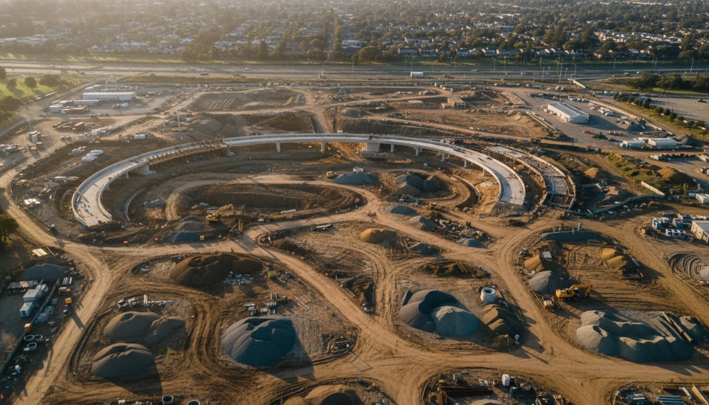
The scale of projects like the North East Link, Suburban Rail Loop (SRL) East, and SRL Airport is truly staggering. These aren’t just roads and rail lines; they’re arteries of a growing city, designed to improve connectivity and future-proof Victoria. To manage such complexity, traditional surveying methods simply aren’t enough. Aerial surveying, powered by state-of-the-art drone technology, offers an unparalleled view and level of detail.
Our expert pilots and geospatial technicians deploy drones equipped with high-resolution cameras to capture millions of data points across vast areas. This data forms the backbone of critical processes:
- Topographic Mapping: Creating incredibly accurate, up-to-date maps of the terrain, essential for planning and design.
- Earthworks Monitoring: Tracking every cubic metre of earth moved, ensuring adherence to design specifications and optimising logistics.
- Volumetric Analysis: Precisely calculating volumes of cut and fill, vital for budget control and material management.
These detailed insights are crucial for project managers overseeing the intricate construction phases of Box Hill’s evolving landscape, from the widening of the Eastern Freeway to the complex interchanges taking shape.
Beyond The Blueprint: The Power of Photogrammetry and 3D BIM
The raw data captured by our drones is just the beginning. Through sophisticated photogrammetry techniques, we transform thousands of overlapping aerial images into highly accurate 3D models and orthomosaics. This process creates a digital twin of the construction site, offering a dynamic and measurable representation of reality. This isn’t merely about pretty pictures; it’s about actionable intelligence.
What truly sets our service apart is the seamless integration of this aerial data into 3D Building Information Modelling (BIM) platforms. Aerial photogrammetry and 3D mapping provide the geometric accuracy and real-world context that BIM models thrive on. This synergy allows engineers and project stakeholders to:
- Visualise the project in real-time 3D against design models.
- Identify potential clashes and discrepancies early, saving time and costly rework.
- Track progress against schedule with unprecedented accuracy.
- Facilitate better communication and collaboration across all project teams.
For large-scale public transport and road infrastructure projects like the North East Link, the ability to integrate real-world site conditions directly into BIM is revolutionary. It translates into safer construction sites, more efficient resource allocation, and ultimately, better outcomes for the community of Box Hill and wider Victoria.
SkyShots: Your Partner in Box Hill’s Development
At SkyShots, we understand the unique challenges and opportunities presented by Box Hill’s rapid development. From the precision required for complex flyovers near the bustling Box Hill Gardens to the comprehensive overview needed for suburban rail extensions, our expertise delivers. We pride ourselves on providing not just data, but solutions that drive efficiency and success for some of Australia’s most ambitious construction projects.
Whether it’s documenting milestones, ensuring compliance, or providing crucial data for design optimisation, our team is equipped to elevate your project with unparalleled aerial insights. Witnessing the transformation of Box Hill from above offers a unique perspective on progress, and we are thrilled to be part of that story.
Ready to see how aerial technology can transform your next infrastructure project in Box Hill or beyond? Contact SkyShots today to discuss your specific needs and discover the SkyShots difference.
Leave a Reply