Cheltenham, a vibrant hub within Melbourne’s southeast, is witnessing significant growth and development. For project managers and stakeholders overseeing this transformation, precision and efficiency are paramount. This is where Cheltenham Drone Construction Site Monitoring Experts like SkyShots become an indispensable asset, revolutionising how construction progress is tracked and managed. Our advanced aerial solutions provide unparalleled insights, ensuring your projects stay on schedule and within budget, especially with the region’s involvement in multi-billion-dollar infrastructure megaprojects like SRL East, SRL Airport, and North East Link traversing these specific established corridors.
The SkyShots Advantage: Precision from Above
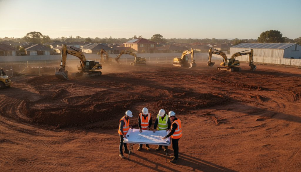
Traditional construction monitoring methods can be time-consuming, costly, and often lack the comprehensive detail needed for complex projects. SkyShots leverages cutting-edge drone technology to deliver accurate, real-time data, transforming project oversight. Imagine the sweeping views near the Bay Road industrial precinct, meticulously captured to inform your decisions.
Beyond Basic Photos: Advanced Data Collection
- Topographic Mapping: Generating highly accurate 2D maps and 3D models of your site, essential for initial planning and ongoing progress tracking.
- Earthworks Monitoring: Precisely measuring cut and fill volumes, enabling efficient management of materials and resources.
- Volumetric Analysis: Quantifying stockpiles and excavations with unprecedented accuracy, providing critical data for budgetary control.
- 3D BIM Integration: Seamlessly integrating drone-captured data into Building Information Modelling (BIM) workflows, enhancing collaboration and reducing errors.
- Photogrammetry: Utilising sophisticated photogrammetric techniques to create highly detailed and measurable digital twins of your construction site.
This comprehensive data empowers project managers to make informed decisions, identify potential issues early, and optimise resource allocation.
Real-World Impact in Cheltenham’s Development
Whether it’s a commercial development near Nepean Highway or a residential complex budding in the quieter streets, drone monitoring offers tangible benefits. Consider the complex logistics involved in the upcoming rail projects impacting the area; detailed aerial insights can mitigate risks and streamline operations. Our aerial perspective provides a holistic view, revealing patterns and progress that ground-level inspections simply cannot.
By regularly deploying our drones, you gain a clear, documented timeline of your project’s evolution. This isn’t just about pretty pictures; it’s about actionable intelligence. From tracking the exact progress of earthworks to ensuring compliance with safety regulations and even spotting potential issues before they escalate, our service is a proactive tool for success.
Why Choose SkyShots for Your Next Cheltenham Project?
As local experts, SkyShots understands the unique landscape and development needs of Cheltenham. We are committed to providing reliable, professional, and precise aerial solutions tailored to your specific project requirements. Our team is fully licensed and insured, adhering to all Australian aviation regulations, ensuring a safe and compliant operation every time. We understand the importance of clear communication and delivering data that integrates seamlessly into your existing project management tools.
Ready to elevate your project oversight and harness the power of aerial intelligence? Visit our construction monitoring services page to learn more about how SkyShots can transform your workflow. Discover our full range of aerial photography and videography services across Australia. You can also explore the official Suburban Rail Loop website for more information on these crucial infrastructure developments impacting our region, or learn about local planning on the City of Kingston’s website. Let SkyShots be your eyes in the sky, ensuring your Cheltenham project reaches new heights of efficiency and success.
Leave a Reply