Box Hill, a vibrant hub in Melbourne’s east, is currently at the epicentre of unprecedented infrastructure development. With multi-billion-dollar projects like the Suburban Rail Loop (SRL) East, SRL Airport connection, and North East Link traversing these established corridors, the demand for precision and efficiency in monitoring and planning is paramount. This is where Box Hill environmental aerial photogrammetry for SRL East corridor projects becomes an indispensable tool, offering unparalleled insights into site development and environmental impact.
Revolutionising Infrastructure with Box Hill Drone Photogrammetry
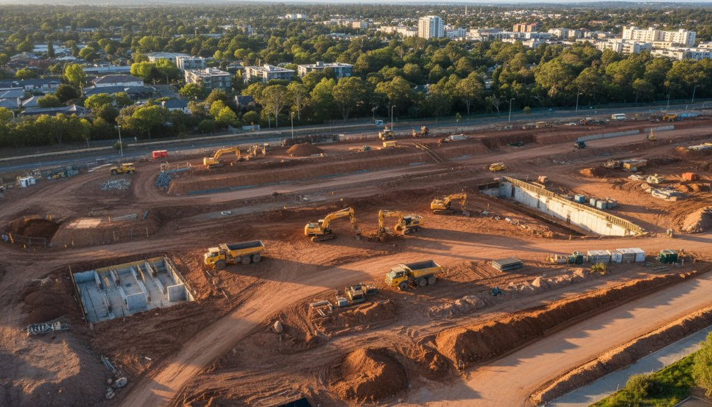
The scale of these megaprojects demands more than traditional survey methods. SkyShots leverages cutting-edge drone technology to provide comprehensive environmental aerial portraits that go beyond simple imagery. Our services offer crucial data for every stage of infrastructure development:
- Topographic Mapping: Generating highly accurate digital terrain models crucial for initial planning, design, and site analysis. This precision ensures that new developments integrate seamlessly with Box Hill’s existing landscape, from its bustling commercial centre near Box Hill Central to its serene residential streets.
- Earthworks Monitoring: Regular aerial surveys allow for precise tracking of excavation and fill operations. This ensures compliance with project specifications, identifies potential issues early, and optimises resource allocation. Imagine monitoring the intricate earthmoving for the SRL East tunnelling, ensuring every cubic metre is accounted for.
- Volumetric Analysis: Accurately calculating material quantities for cut-and-fill operations, stockpiles, and material removal. This not only saves costs but also enhances project efficiency, providing real-time data for better decision-making on Box Hill’s vast construction sites.
- 3D BIM Integration: Our photogrammetry outputs are seamlessly integrated into Building Information Modelling (BIM) workflows. This provides a holistic, data-rich 3D model that enhances collaboration, reduces errors, and improves overall project delivery for complex structures within the SRL East and North East Link precincts.
Beyond Mapping: Data-Driven Insights for Box Hill’s Future
The environmental aspect of these infrastructure projects in Box Hill cannot be overstated. Aerial photogrammetry provides a non-invasive, highly detailed method for monitoring environmental corridors, ensuring that construction adheres to strict environmental guidelines. From assessing vegetation changes along the North East Link route to monitoring water runoff and erosion control measures, our drone technology delivers actionable intelligence.
Imagine tracking the green spaces around Box Hill’s parks and recreational areas, ensuring minimal disruption during major works. Our high-resolution imagery and precise data collection facilitate proactive environmental management strategies, helping to preserve the unique character and natural beauty of the Box Hill region, even amidst significant development. We provide the detailed visual evidence needed to make informed decisions about mitigating impact and fostering sustainable development.
SkyShots’ expertise in aerial mapping and surveying means we understand the intricate details required for large-scale infrastructure projects. Our team is adept at navigating the complexities of urban environments like Box Hill, ensuring safe and efficient data capture. We pride ourselves on delivering not just images, but comprehensive data solutions that empower project managers, engineers, and environmental consultants.
For more insights into large-scale infrastructure developments in Victoria, you can explore information from the Victorian Big Build website, which details projects like the Suburban Rail Loop. The local Whitehorse City Council also provides updates on significant infrastructure shaping the Box Hill area.
Whether it’s providing crucial topographic data for initial planning, monitoring earthworks progress, or integrating detailed 3D models into BIM systems, SkyShots is your trusted partner. We deliver the precision, detail, and actionable insights needed to ensure the success of Box Hill’s transformative infrastructure megaprojects. Discover how our advanced drone capabilities can elevate your next project by visiting our contact page.
Leave a Reply