Box Hill is a dynamic hub in Melbourne’s eastern suburbs, constantly evolving with a blend of vibrant community life and significant development. In this bustling landscape, Box Hill Aerial Portraits Capturing Infrastructure Progress offer a unique, bird’s-eye view into the monumental changes taking shape. From the bustling Box Hill Central precinct to its leafy residential pockets, the suburb’s transformation is undeniable, with grand infrastructure projects playing a pivotal role. SkyShots provides unparalleled aerial photography services to document this evolution, offering both breathtaking visuals and invaluable data.
Capturing Box Hill’s Evolving Infrastructure: More Than Just a Snapshot
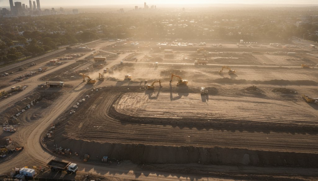
The corridors of Box Hill are currently witnessing the extraordinary scale of multi-billion-dollar infrastructure megaprojects, such as the Suburban Rail Loop (SRL) East and elements of the North East Link. These ambitious undertakings are reshaping the region, demanding precision and meticulous oversight. At SkyShots, we go beyond simple photographs, creating detailed aerial ‘portraits’ of these individual project sites. Our drones capture the sheer scale and intricate details of development, turning complex construction zones into compelling visual narratives. We help stakeholders visualise progress and impact, from the initial earthworks through to structural completion.
Precision in Detail: Topographic Mapping and Beyond
Our advanced drone technology enables far more than just stunning visuals. We specialise in critical services that provide tangible benefits for project management in Box Hill:
- Topographic mapping: Providing highly accurate data for planning and execution, crucial for projects of any scale.
- Earthworks monitoring: Tracking progress and ensuring compliance, identifying discrepancies swiftly to keep projects on schedule.
- Volumetric analysis: Essential for calculating material quantities in real-time, optimising resource management and minimising waste on expansive sites.
- 3D BIM integration: Transforming aerial data into precise Building Information Models that enhance project coordination and visualisation.
- Photogrammetry: Utilising state-of-the-art techniques to convert multiple overlapping images into detailed 2D maps and 3D models, offering unparalleled insights into site conditions and progress.
These individual aerial ‘portraits’ provide comprehensive data, invaluable for developers, construction firms, and urban planners keen to document and understand Box Hill’s rapid development. Our imagery helps you accurately monitor progress, identify potential issues, and communicate effectively with all project stakeholders.
The SkyShots Advantage: Elevating Your Box Hill Projects
As local experts, SkyShots understands the unique landscape and development trajectory of Box Hill. We recognise the importance of documenting every stage of progress, especially for projects as significant as the SRL East and North East Link which traverse established corridors. Our high-resolution aerial photography and data capture capabilities ensure you receive the most accurate and visually stunning records. Whether it’s an ongoing commercial build near the vibrant Box Hill Central, or a complex infrastructure development requiring detailed analytics, our team is equipped to deliver.
We pride ourselves on professionalism, safety, and a keen eye for detail, ensuring every aerial shot serves a purpose – be it for marketing, progress reports, or compliance. Our portfolio of work showcases how we capture the dynamic evolution of diverse projects, helping our clients tell their story from a unique vantage point.
Whether you’re overseeing a major infrastructure project, managing a commercial development, or simply seeking to capture the unique architectural ‘portrait’ of an individual site in Box Hill, SkyShots is your trusted partner. Our commitment to precision, safety, and stunning visual storytelling ensures your project’s aerial narrative is perfectly documented. Contact SkyShots today to discuss how we can elevate your perspective and capture the dynamic evolution of Box Hill.
Leave a Reply