In the dynamic landscape of modern development, visual clarity is paramount. For heavy civil and transport infrastructure projects in Cheltenham, Australia, the ability to gain comprehensive, real-time perspectives from above is not just an advantage – it’s a necessity. This is where Cheltenham civil infrastructure drone photography by SkyShots truly shines, offering unparalleled insights that transform planning, execution, and communication.
Cheltenham, with its evolving industrial hubs and critical transport arteries like the Nepean Highway, is a focal point for infrastructure growth. Understanding the intricate details of large-scale projects, from road upgrades to utility installations, requires more than just ground-level observation. Drones provide that crucial aerial vantage point, allowing project managers, engineers, and stakeholders to monitor progress, identify potential issues, and ensure compliance with unprecedented accuracy and efficiency.
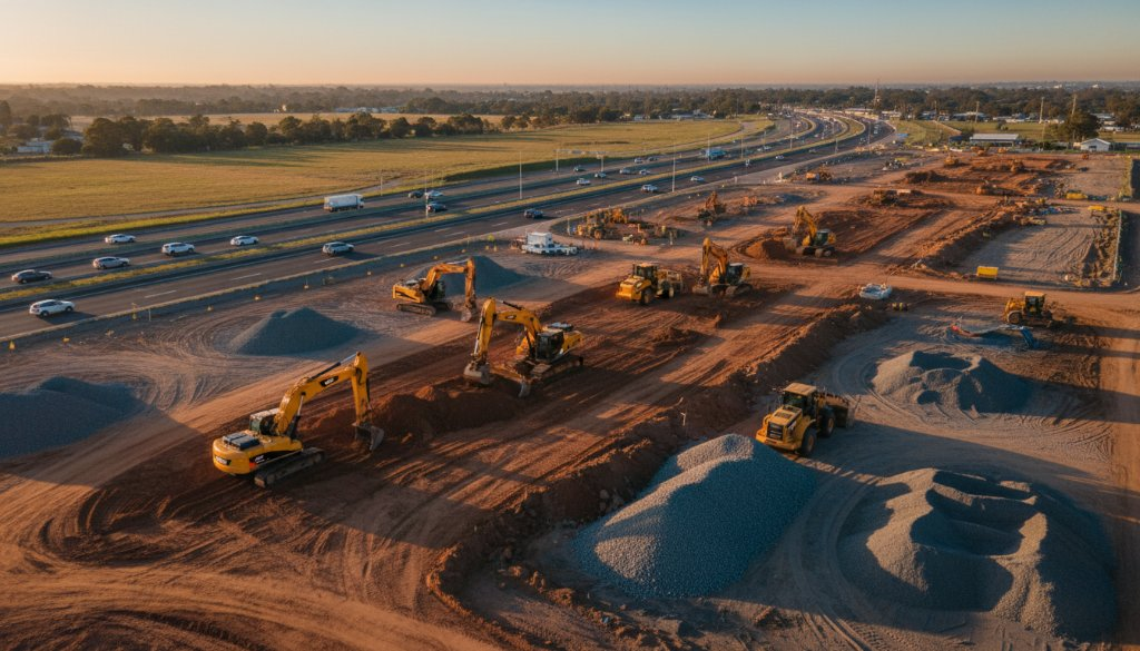
Elevating Cheltenham’s Transport & Civil Projects
SkyShots specialises in providing high-resolution aerial imagery and data collection specifically tailored for the heavy civil and transport infrastructure sector. Our drones capture stunning visuals that serve multiple purposes:
- Detailed Site Surveys: Before a single shovel hits the ground, our aerial surveys provide precise topographical data, helping with initial planning and design phases.
- Progress Monitoring: Regular drone flights offer consistent, measurable updates on construction progress. Track earthworks, material staging, and installation timelines with visual evidence.
- Asset Inspection: From bridges to pipelines, complex infrastructure assets can be inspected safely and efficiently, identifying maintenance needs without putting personnel at unnecessary risk.
- Environmental Impact Assessments: Documenting the surrounding environment before, during, and after construction helps ensure projects meet local regulations and minimise ecological footprints.
Beyond the Ground: Unmatched Perspective
Our drone solutions go beyond simple photographs. We deliver geo-referenced imagery, orthomosaics, 3D models, and point clouds that integrate seamlessly with existing CAD and GIS software. This level of detail empowers your team to make informed decisions, mitigate risks, and streamline workflows. Discover the full spectrum of our comprehensive aerial services tailored for infrastructure projects.
Supporting Local Development in Kingston City
As Cheltenham continues its growth within the City of Kingston, new infrastructure is constantly being developed to support its residents and businesses. SkyShots is proud to partner with local councils, developers, and contractors to ensure these vital projects are executed with precision and transparency. We understand the specific challenges and opportunities within the Melbourne metropolitan area and are committed to delivering results that contribute to the region’s prosperity. For more information on local development, visit the Kingston City Council website. You can also explore our portfolio to see examples of our work on similar projects.
Visual documentation captured by SkyShots aids not only in operational efficiency but also in stakeholder communication. Presenting clear, compelling aerial visuals helps convey project scope and progress to investors, community members, and regulatory bodies, fostering trust and transparency.
For your next heavy civil or transport infrastructure project in Cheltenham, don’t just see it – truly understand it from a new perspective. Contact SkyShots today to discuss how our expert drone photography can elevate your project’s success. Let us help you capture the full picture, ensuring your vision takes flight.
Leave a Reply