Cheltenham, a vibrant hub in Melbourne’s southeast, is currently undergoing a significant transformation, with multi-billion-dollar infrastructure megaprojects like the Suburban Rail Loop (SRL East), SRL Airport, and North East Link traversing its established corridors and neighbouring areas. These ambitious undertakings demand unparalleled precision and insight, making expert Cheltenham Infrastructure Drone Photography an indispensable tool for project managers and developers. At SkyShots, we’re at the forefront of this evolution, providing detailed aerial perspectives that are crucial for monitoring progress, ensuring safety, and achieving project milestones efficiently.
The Precision Behind Major Infrastructure Projects in Cheltenham
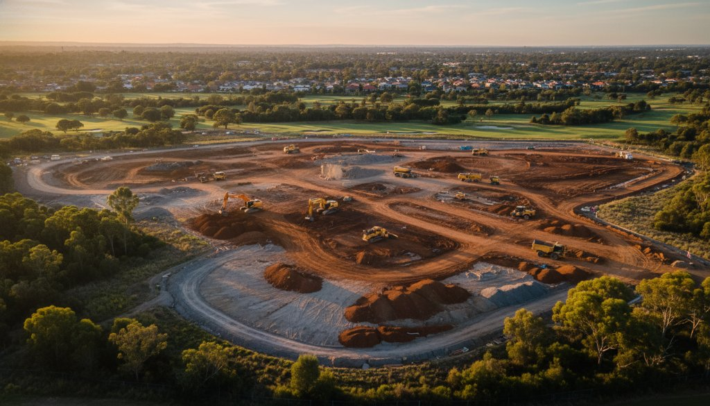
The scale of development in and around Cheltenham, from the massive SRL East tunnelling efforts to ongoing road upgrades, requires a sophisticated approach to data acquisition. Traditional ground surveys can be time-consuming and hazardous. This is where SkyShots excels, offering comprehensive aerial solutions tailored to the unique demands of large-scale infrastructure. We don’t just take pictures; we provide actionable intelligence.
Our advanced drone technology enables precise topographic mapping, creating highly accurate digital elevation models that are vital for initial planning and ongoing adjustments. For dynamic sites, continuous earthworks monitoring ensures that ground movement and material displacement are tracked with meticulous detail. Furthermore, our services extend to robust volumetric analysis, providing accurate calculations of cut and fill operations – a critical component for budgeting and progress reporting on projects near areas like the Moorabbin Airport precinct or along the busy Nepean Highway.
Integrating Aerial Data for Smart Development
The true power of modern aerial photography lies in its integration with existing project management frameworks. SkyShots leverages cutting-edge photogrammetry techniques to transform raw aerial images into highly detailed 3D models. These models are then seamlessly integrated into 3D Building Information Modelling (BIM) systems, offering a holistic view of the project lifecycle. This 3D BIM integration allows stakeholders to visualise progress, identify potential clashes, and make informed decisions with unparalleled clarity. Imagine monitoring the progress of a new overpass or the expansion of a commercial complex near Westfield Southland, all from a precise, up-to-date aerial perspective – it’s an invaluable asset for efficient project delivery.
The environmental considerations within these projects are also paramount. By capturing frequent, high-resolution aerial imagery, we help document changes, assess ecological impact, and support compliance reporting, ensuring development in areas like Cheltenham remains as sustainable as possible. Our detailed environmental aerial portraits offer a unique vantage point, revealing the intricate dance between human innovation and the natural landscape.
SkyShots: Your Partner for Cheltenham Infrastructure Drone Photography
Choosing SkyShots means partnering with a local Australian team that understands the specific challenges and opportunities presented by Cheltenham’s rapidly evolving landscape. We’re not just drone operators; we’re problem-solvers dedicated to providing you with the most accurate, timely, and visually compelling data possible. Whether it’s tracking progress for a new section of the Suburban Rail Loop, conducting pre-construction surveys for commercial developments in the industrial zones, or ensuring safety compliance on sensitive sites, our expertise delivers tangible value.
Our commitment to safety, compliance, and exceptional image quality ensures that your project data is always reliable. We pride ourselves on capturing those critical moments and comprehensive overviews that define the success of your infrastructure project. From the early stages of site preparation to final construction, SkyShots provides the visual intelligence you need to keep your Cheltenham project on track and within budget.
Ready to elevate your project’s monitoring capabilities? Discover the SkyShots difference in professional aerial photography and mapping services. Contact us today to discuss how our bespoke solutions can provide the clarity and precision your Cheltenham infrastructure project demands.
Leave a Reply