Officer site progress aerial photography is becoming an essential tool for developers and project managers working within one of Melbourne’s fastest-growing corridors. As Officer transforms from a quiet semi-rural pocket into a thriving residential hub, the need for precise, high-resolution visual documentation has never been higher. At SkyShots, we specialise in capturing the evolution of these sites, providing stakeholders with a bird’s-eye view that traditional ground-level photography simply cannot match.
The Benefits of Officer Site Progress Aerial Photography
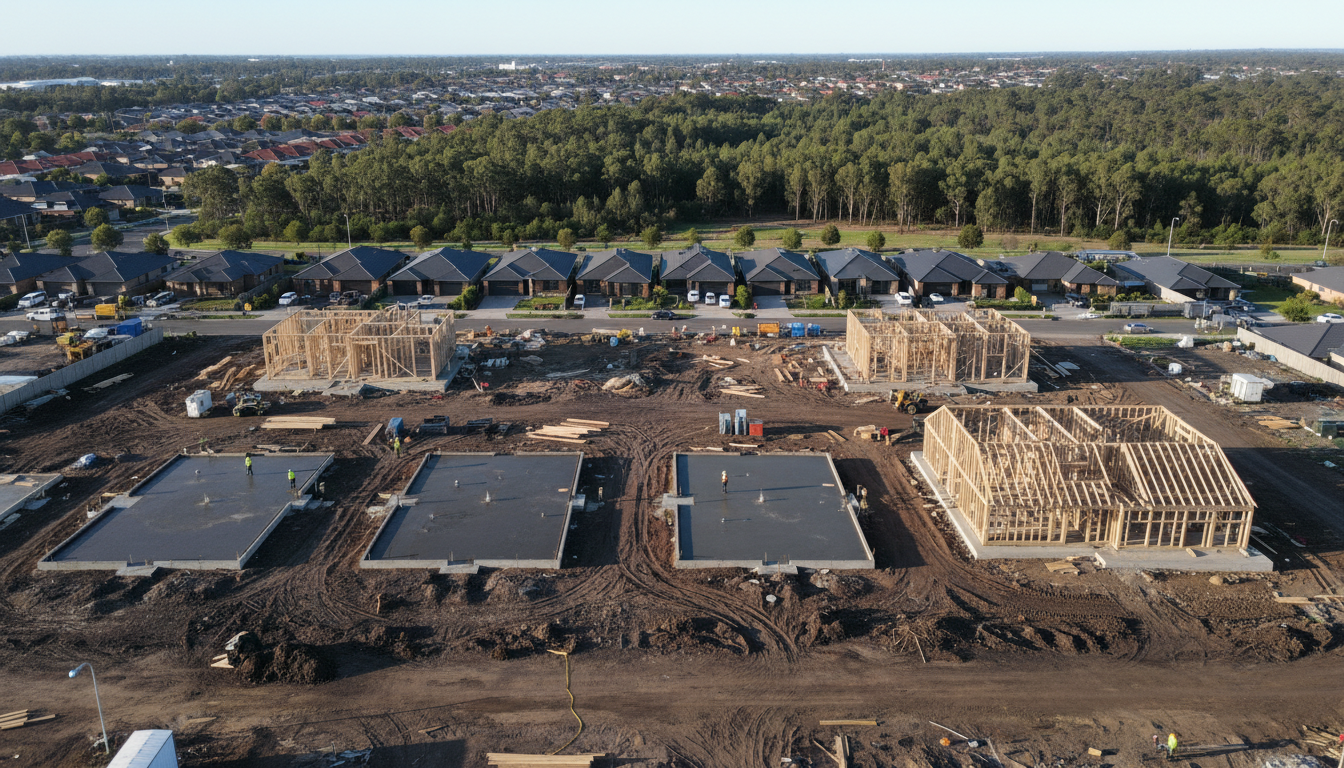
With major developments like the Timbertop Estate and the bustling commercial zones near the Officer train station, the landscape is shifting daily. Utilizing Officer site progress aerial photography allows construction firms to monitor earthworks, structural developments, and landscaping milestones with absolute accuracy. This data is not just for marketing; it is a critical component of modern site management and stakeholder reporting.
By integrating drone imagery into your workflow, you can identify potential bottlenecks before they become costly delays. For instance, an aerial sweep of a site near Cardinia Creek can reveal drainage issues or soil distribution patterns that are invisible from the ground. Our team at SkyShots ensures that every flight is planned to capture consistent angles, making it easy to create before-and-after comparisons that showcase the rapid pace of growth in the region.
Enhancing Stakeholder Communication
Transparency is key in large-scale residential projects. When you provide investors or future homeowners with a clear, high-definition update of their property, you build trust. Many of our clients in the Cardinia Shire use these images to update their social media channels and official project portals. Seeing a roof go on or a parkland being shaped near the Officer District Park provides a tangible sense of progress that words alone cannot convey.
Our services extend beyond simple stills. We offer comprehensive construction photography packages that include 4K video walkthroughs and orthomosaic mapping. This level of detail is vital for large-scale infrastructure projects where every millimetre counts. Whether it is a new school building or a multi-stage housing estate, our pilots are fully licensed and experienced in navigating the unique airspace of Melbourne’s outer south-east as outlined by the Victorian Planning Authority.
Why Choose SkyShots for Your Next Project?
At SkyShots, we pride ourselves on our professional approach and our deep understanding of the local Officer area. We do not just take photos; we capture the narrative of construction. Our equipment is state-of-the-art, ensuring that every colour is true to life and every detail is crisp, even in the challenging light of a Victorian winter morning. If you are looking to elevate your project reporting and marketing, consider how aerial site updates can streamline your operations. From the initial breaking of ground to the final handover, we are here to document every milestone. Contact the team at SkyShots today to discuss your specific requirements and let us help you see your Officer project from a whole new perspective.
Leave a Reply