Optimising Watsonia’s Infrastructure with Aerial Precision
In the bustling Melbourne neighbourhood of Watsonia, civil construction projects are constantly shaping the landscape, from vital road upgrades to essential utility installations. For these complex undertakings, achieving efficiency, accuracy, and safety is paramount. This is where precision drone mapping Watsonia civil construction truly shines, transforming how projects are planned, monitored, and executed. SkyShots, as your local aerial photography experts, brings unparalleled insights to every phase of your infrastructure development.
Watsonia, a suburb known for its connectivity and community, particularly benefits from advanced technologies that streamline construction. Whether it’s enhancing the flow of traffic along Watsonia Road or upgrading vital services that support our growing community, the demand for meticulous project oversight is higher than ever. Drones offer a bird’s-eye view that traditional ground surveys simply cannot match, providing comprehensive data swiftly and safely.
The Power of Precision Drone Mapping in Watsonia
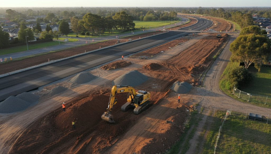
The application of drone technology in heavy civil and transport infrastructure projects offers a multitude of advantages. At its core, precision drone mapping provides highly accurate topographical data, volumetric calculations, and detailed progress reports. This data is invaluable for:
- Initial Site Surveys: Quickly generating accurate 3D models and orthomosaic maps to inform design and planning.
- Progress Monitoring: Regular aerial scans allow project managers to track construction progress against schedules, identify potential bottlenecks, and ensure resources are optimally utilised.
- Safety Enhancements: Inspecting hard-to-reach or hazardous areas without putting personnel at risk, adhering to stringent Australian safety standards.
- Stakeholder Communication: Providing clear, visual evidence of project milestones and challenges to all involved parties, from investors to local council members.
For projects near key Watsonia arteries like the Greensborough Highway or the local train line, understanding the terrain and surrounding environment with absolute clarity is non-negotiable. Our drones capture every detail, ensuring your project is built on a foundation of solid, verifiable data.
Beyond Traditional Methods: Why Drones are Essential for Civil Projects
Gone are the days when civil engineers relied solely on ground teams for surveys, which could be time-consuming, costly, and sometimes inaccurate over large areas. Drone technology offers a rapid, cost-effective, and incredibly precise alternative. A single drone flight can capture data that would take a ground crew days or even weeks to collect, significantly accelerating project timelines. This efficiency is particularly crucial in the fast-paced world of Watsonia’s infrastructure development, where delays can have substantial financial and community impacts.
Moreover, the data captured by drones can be integrated with Building Information Modelling (BIM) software, Geographic Information Systems (GIS), and Computer-Aided Design (CAD) platforms, creating a holistic and intelligent approach to project management. This synergy allows for predictive analytics, better resource allocation, and proactive problem-solving, all contributing to superior project outcomes.
SkyShots’ Expertise in Watsonia’s Civil Projects
As local experts, SkyShots understands the unique challenges and opportunities within Watsonia and the wider Melbourne region. Our team is equipped with state-of-the-art drone technology and an in-depth understanding of civil construction requirements. We don’t just fly drones; we provide actionable intelligence that empowers your team to make informed decisions. We’re proud to support the development of our local community, contributing to safer, more efficient, and more sustainable infrastructure.
From the early planning stages to the final inspections, our aerial photography and data capture services are tailored to meet the specific needs of your civil project. We ensure that every detail, every contour, and every cubic metre is accounted for, providing you with the confidence to proceed with precision.
Ensuring Project Success from Above
The benefits extend beyond mere data collection. With SkyShots, you gain a dedicated partner committed to the success of your Watsonia project. Our detailed reports and high-resolution imagery allow for early detection of potential issues, minimising costly rework and keeping projects on track and within budget. We can help you track earthworks, monitor material stockpiles, and assess environmental impacts, all from a safe, elevated perspective.
For more information on infrastructure development in Victoria, you can visit the Department of Transport and Planning Victoria website. To understand local council planning and development in Watsonia, the Banyule City Council offers valuable resources.
When it comes to the intricate world of heavy civil and transport infrastructure, precision is not just a preference; it’s a necessity. Let SkyShots provide the aerial advantage your Watsonia civil construction project needs to succeed. Reach out today to discuss how our expert drone mapping services can elevate your next endeavour.
Leave a Reply