The vast, rugged landscapes of Australia often hide stories waiting to be told, and sometimes, the best way to tell them is from above. In Rockbank, Victoria, one such story unfolds around its remarkable quarry. At SkyShots, we specialise in revealing these narratives through breathtaking aerial photography, offering unparalleled Rockbank historic quarry aerial detail insights. From high above, the very contours of the land whisper tales of industry, geology, and time, transforming a familiar site into an awe-inspiring spectacle.
Unearthing Rockbank’s Past from a New Vantage
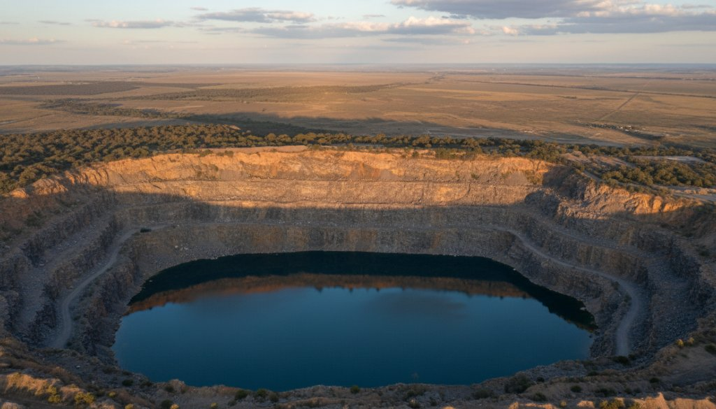
The Rockbank Quarry isn’t just a hole in the ground; it’s a significant landmark etched into Victoria’s history. For decades, it was a bustling site, contributing vital basalt to the construction of Melbourne’s roads and infrastructure. From the ground, one can appreciate its scale, but it’s only from an aerial perspective that its true grandeur and the intricate patterns left by years of excavation become truly apparent. Drone photography allows us to trace the lines of geological strata, the pools of vibrant blue water, and the dramatic cliffs that tell a story of human endeavour meeting natural power.
Our drone operators meticulously capture the quarry’s unique features, from the deep, almost obsidian-like basalt formations to the surprising pockets of vegetation clinging to its edges. These detailed shots provide an invaluable record, not only for historical preservation but also for anyone wanting to understand the very fabric of this part of Australia. The distinctive Western Volcanic Plains, upon which Rockbank sits, are notoriously flat, making the quarry’s dramatic elevation changes even more striking when viewed from the sky. For a glimpse into the diverse applications of our work, explore our commercial aerial photography portfolio.
The Art of Aerial Storytelling in Rockbank
What makes aerial photography of a landmark like the Rockbank Quarry so compelling? It’s the ability to present an entirely new context. Shadows play across the landscape in ways impossible to observe from eye level, highlighting textures and depths that might otherwise go unnoticed. The sheer scale of the operation, the careful planning of extraction, and the eventual reclaiming by nature are all laid bare in a single frame. We don’t just take pictures; we craft visual narratives that resonate with the essence of the location.
Our team at SkyShots understands the delicate balance required to capture these moments responsibly and artistically. We navigate the skies with precision, ensuring every image reflects the true spirit of Rockbank while adhering to the highest safety and ethical standards. Whether it’s capturing the morning mist clinging to the quarry’s rim or the golden hour sun setting the rock faces ablaze, our goal is to deliver images that are not just photographs but windows into the soul of a place.
Beyond the quarry itself, Rockbank and the wider Melton area boast a burgeoning community and a blend of rural charm with growing urban development. Understanding these local nuances is key to our approach, ensuring our aerial insights are always relevant and respectful of the area’s character. For more information on the local area’s development and natural heritage, you can visit the City of Melton website.
Preserving Rockbank’s Legacy Through Drone Photography
The historical significance of the Rockbank Quarry, and landmarks like it across Victoria, cannot be overstated. By providing crystal-clear Rockbank historic quarry aerial detail insights, SkyShots contributes to a visual archive that helps preserve these important sites for future generations. Our work is often utilised by local councils, historical societies, and developers who seek to understand and showcase the unique heritage and potential of an area. Furthermore, organisations like Heritage Victoria regularly rely on detailed visual documentation to assess and protect significant sites.
Imagine being able to see the full expanse of the quarry, its transformation over time, and its integration into the surrounding environment, all captured with stunning clarity. This is the power of professional aerial photography. It transforms data into art, and history into a living, breathing landscape.
Ready to see your project or landmark from an extraordinary new perspective? Whether it’s for historical documentation, environmental monitoring, or simply appreciating the beauty of our Australian landscape, SkyShots is your trusted partner for premium aerial photography services. Contact SkyShots today to discuss how we can bring your vision to life, high above the ground.
Leave a Reply