Tullamarine, a vibrant hub of industry and connectivity just northwest of Melbourne’s CBD, offers a unique visual tapestry when viewed from above. At SkyShots, we specialise in capturing the extraordinary, and our expertise truly shines when it comes to Tullamarine Precinct Aerial Drone Photography Details. From the sprawling runways of Melbourne Airport to the intricate network of logistics parks and commercial centres, aerial perspectives reveal the true scale and dynamism of this pivotal Victorian location.
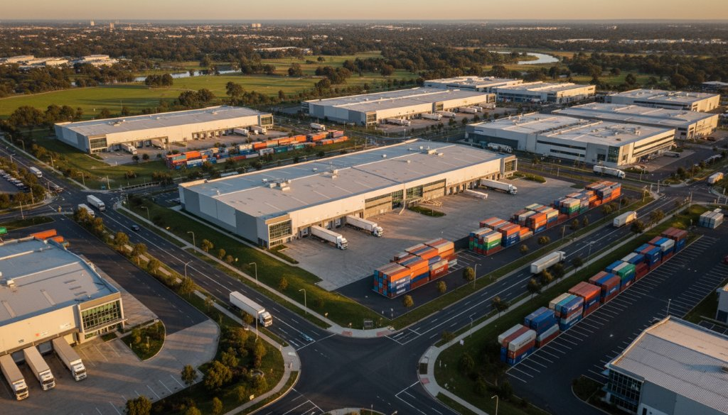
Known primarily as the gateway to Melbourne via its international airport, Tullamarine is much more than just a transit point. It’s a rapidly developing commercial and industrial precinct, home to countless businesses, freight operations, and innovative enterprises. Capturing the essence of this dynamic area requires a keen eye and the advanced capabilities of professional drone photography. Unlike ground-level shots, aerial photography can highlight the efficient layouts of business parks, the flow of traffic, and the strategic positioning of facilities, all of which are crucial details for stakeholders.
The Sky-High Advantage for Tullamarine Businesses
For businesses operating within Tullamarine, high-quality aerial photography is an invaluable asset. Whether for showcasing vast properties, documenting construction progress, or creating compelling marketing materials, the advantage of a bird’s-eye view is undeniable. Imagine displaying the full scope of your warehouse facility, its proximity to major transport links like the Western Ring Road, or the architectural nuances of a new commercial development. These are the details that truly differentiate and impress.
SkyShots combines cutting-edge drone technology with a deep understanding of local regulations and aesthetics. Our licensed and experienced pilots ensure every shot is not only spectacular but also legally compliant and safe, especially when operating in the vicinity of significant infrastructure like Melbourne Airport. We pride ourselves on delivering visuals that tell a story, capturing the scale, the detail, and the unique character of the Tullamarine landscape.
The Rich Tapestry of Tullamarine’s Aerial Details
Beyond the immediate vicinity of the airport, Tullamarine’s precinct extends to various business parks, freight terminals, and even pockets of natural beauty along waterways such as the Maribyrnong River. Our drone photography captures these diverse elements, from the precision of logistics operations to the unexpected green spaces that punctuate the urban sprawl. We offer services tailored to a multitude of needs, including commercial real estate listings, infrastructure project monitoring, and marketing campaigns that demand a fresh, impactful perspective.
Exploring Tullamarine from above provides insights into urban planning and the intricate dance of commerce. The patterns created by road networks, the distinct colours of industrial roofing, and the sprawling car parks all contribute to a unique visual identity. We invite you to explore the possibilities of professional aerial photography services to truly elevate your visual content.
SkyShots is your trusted partner for drone photography across Melbourne and beyond. We understand the local environment of Tullamarine, ensuring that every project is executed with precision, professionalism, and a creative flair that captures the very best of this dynamic Australian location. Discover more about what makes Tullamarine tick from an entirely new vantage point.
To learn more about Tullamarine’s vibrant community and ongoing developments, you can visit the Melbourne Airport official website or explore broader regional information on Visit Victoria. Let SkyShots help you uncover and present the stunning visual narratives held within Tullamarine.
Ready to see your Tullamarine project from an unparalleled perspective? Contact SkyShots today to discuss how our expert aerial photography can bring your vision to life.
Leave a Reply