Box Hill Aerial Insights: Monitoring SRL East Infrastructure Progress
In the vibrant heart of Melbourne’s east, Box Hill stands as a bustling hub, a testament to multiculturalism and dynamic growth. As this thriving community continues to evolve, it’s also at the epicentre of some of Australia’s most ambitious infrastructure undertakings. Here at SkyShots, we provide crucial Box Hill Aerial Insights: Monitoring SRL East Infrastructure Progress, offering unparalleled precision and oversight for these monumental projects.
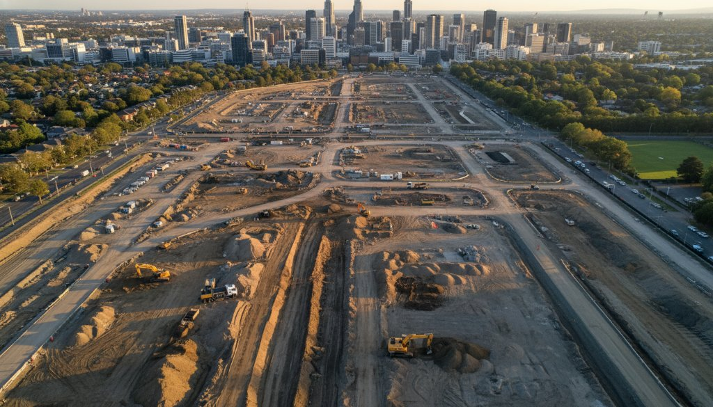
Box Hill’s strategic location makes it a key gateway, and with multi-billion-dollar infrastructure megaprojects like the Suburban Rail Loop (SRL) East, SRL Airport connection, and the North East Link traversing these established corridors, the demand for meticulous oversight has never been greater. These aren’t just lines on a map; they are the arteries of future connectivity, shaping how millions of Victorians will live, work, and commute.
The SkyShots Advantage: Precision for Megaprojects in Box Hill
For projects of this magnitude, traditional surveying methods simply cannot keep pace with the speed and scale of development. This is where SkyShots excels. Our advanced drone technology provides comprehensive aerial data crucial for every stage of infrastructure development, particularly within the complex urban fabric of Box Hill. We understand the specific challenges of working within a high-density area, from managing logistics around Box Hill Central to understanding the unique topography of the surrounding neighbourhoods.
Our drone services offer more than just pretty pictures. We deliver actionable intelligence through:
- Topographic mapping: Creating highly accurate 3D models of the terrain to inform design and planning.
- Earthworks monitoring: Tracking cut and fill volumes with exceptional precision, ensuring adherence to design specifications and optimising material management.
- Volumetric analysis: Quantifying material stockpiles and excavation progress, a critical component for budget and schedule control.
- 3D BIM integration: Seamlessly integrating high-resolution photogrammetry data into Building Information Modelling (BIM) workflows, enhancing collaboration and reducing errors.
- Photogrammetry: Capturing millions of data points to generate detailed, georeferenced models of the construction site.
Our commitment to precision ensures that every cubic metre of earth moved and every structural element placed is accounted for. For project managers overseeing the Suburban Rail Loop East or future stages of other major transport links, this data is invaluable. It helps in making informed decisions, mitigating risks, and maintaining project timelines and budgets.
Why Choose SkyShots for Your Box Hill Project?
As a local Australian business, SkyShots brings not just technical expertise but also an intimate understanding of the Box Hill area. We appreciate the community’s needs and the significance of these projects for its future. Our professional pilots are CASA-certified, ensuring all operations are conducted safely, efficiently, and in full compliance with regulations. We have a proven track record in delivering high-quality construction progress monitoring and 3D mapping and modelling services for complex sites across Australia.
From the bustling Box Hill Gardens to the dynamic retail precincts, we navigate the local landscape with ease, providing comprehensive aerial overviews that capture every detail. Our data helps ensure these colossal projects are built with the highest standards of accuracy, benefiting not only the developers but also the residents of Box Hill.
Partner with SkyShots to gain clear, verifiable insights into your next major infrastructure project in Box Hill. Let us elevate your project oversight to new heights, delivering the precision and clarity you need to succeed.
Leave a Reply