Cheltenham Aerial Photogrammetry for Infrastructure Development: Building Tomorrow
In the vibrant suburb of Cheltenham, where community spirit meets progressive development, the landscape is constantly evolving. From bustling local centres to burgeoning residential areas, every new structure and pathway contributes to the fabric of this dynamic Bayside locale. For those at the forefront of shaping Cheltenham’s future, particularly with the multi-billion-dollar infrastructure megaprojects traversing these specific established corridors, precision is paramount. This is where SkyShots’ expert Cheltenham aerial photogrammetry for infrastructure development becomes an indispensable tool, offering unparalleled insights for planning, monitoring, and execution.
Cheltenham’s strategic location makes it a key beneficiary and participant in Victoria’s ambitious infrastructure undertakings. Megaprojects like the Suburban Rail Loop (SRL East and SRL Airport sections) and the North East Link are not just transforming transport networks but are also spurring significant local architectural and urban development. Navigating these complex projects requires more than traditional surveying; it demands a comprehensive, dynamic, and accurate view from above. Our drone technology provides just that, delivering high-resolution data that underpins critical decision-making.
Precision Data for Progressive Projects
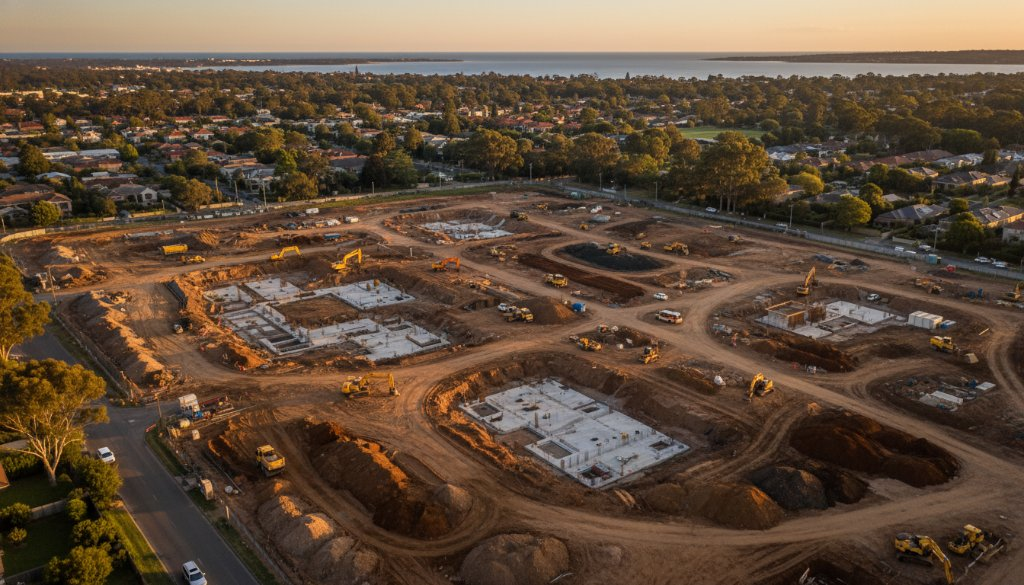
At SkyShots, we understand the intricate demands of large-scale construction and infrastructure. Our aerial photography and photogrammetry services go far beyond simple snapshots. We specialise in generating highly accurate topographic mapping, providing detailed contour information essential for initial site assessments and ground modelling. This level of detail ensures that every earthwork is executed with precision, minimising errors and maximising efficiency from the very first shovel in the ground. Imagine monitoring the excavation for a new SRL station in Cheltenham with centimetre-level accuracy, ensuring compliance and preventing costly rework.
Furthermore, our capabilities extend to advanced earthworks monitoring and volumetric analysis. Whether it’s tracking the movement of fill, calculating cut-and-fill volumes, or verifying material quantities, our aerial data provides real-time, actionable intelligence. This is crucial for managing budgets, optimising logistics, and ensuring that your project stays on schedule. For developers and project managers in Cheltenham, this means a clearer picture of progress and performance, enabling proactive adjustments rather than reactive problem-solving.
Integrating Aerial Insights with 3D BIM
The future of infrastructure development is integrated, and at SkyShots, we are at the forefront of this evolution. Our photogrammetry data seamlessly integrates with 3D Building Information Modelling (BIM) workflows. This powerful synergy allows for the creation of incredibly detailed and accurate digital twins of your project, from existing conditions to proposed designs. By incorporating real-world site data captured from above, BIM models become richer, more precise, and invaluable for clash detection, progress visualisation, and stakeholder communication. Imagine presenting a proposed commercial development near Charman Road with a stunning, accurately mapped 3D model, ensuring all stakeholders are aligned.
The impact of this integration on projects like the North East Link traversing the Cheltenham area is profound. Engineers and architects can overlay proposed designs onto actual site conditions, identifying potential challenges before they escalate. This proactive approach saves time, reduces costs, and enhances collaboration across all project phases. For more information on local development and planning regulations in Victoria, you can visit the Planning Victoria website.
Cheltenham’s distinct character, from its thriving retail precincts to its proximity to the beautiful Port Phillip Bay, means that any development must be undertaken with care and precision. Our aerial expertise not only captures the technical details but also provides stunning visual documentation that respects the aesthetic and environmental context of this cherished suburb. From monitoring progress on significant architectural builds to ensuring the smooth execution of major transport upgrades, SkyShots is your trusted partner.
Ready to elevate your next project in Cheltenham? Discover how SkyShots’ advanced aerial photogrammetry and architectural drone photography can provide the precise data and stunning visuals you need to succeed. Contact us today to discuss your specific requirements and receive a tailored solution that brings your vision to life, from the ground up, with a view from the sky down.
Leave a Reply