The Value of Officer Drone Construction Progress Photography
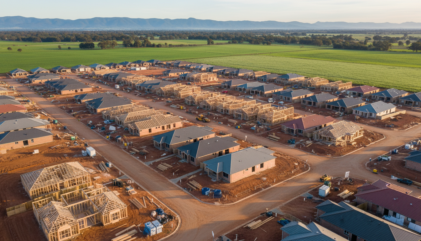
Officer drone construction progress photography is becoming an indispensable tool for project managers and developers across the Cardinia Shire. As the suburb transitions from its semi-rural roots into a bustling residential and commercial hub, the need for precise, real-time visual data has never been higher. SkyShots provides the high-altitude perspective required to oversee every phase of a build, from initial earthworks near the Officer Train Station to the final landscaping of premium estates. By utilising professional drone services, developers can also enhance their marketing efforts and keep project timelines transparent.
The visual documentation provided by aerial platforms offers more than just a bird’s eye view. It creates a chronological record of achievement that is vital for stakeholder reporting and internal audits. This chronological data set allows for precise comparison of month-to-month growth, providing an indisputable record for project partners and insurance purposes. By capturing the same angles at regular intervals, we help project teams identify potential bottlenecks before they become costly delays. For more information on how we support the building industry, explore our aerial photography services. This visual evidence is crucial for maintaining accountability across large-scale infrastructure projects.
Local Expertise in Officer’s Growth Corridor
Working within the local landscape requires an understanding of the specific conditions in Officer. Whether we are navigating the undulating terrain around the Timbertop Estate or capturing the expansive progress of the Kaduna Park precinct, our pilots ensure that every shot is clear and informative. The local government, specifically the Cardinia Shire Council, continues to oversee significant infrastructure projects, making professional monitoring a key component of any major development’s transparency strategy.
A high-resolution image of a site’s progression resonates with potential buyers, showing them that their future home is being built with care and precision. These images highlight the site’s proximity to local amenities like the Arena Shopping Centre, adding a layer of geographic context that ground-level photography simply cannot match. You can see examples of our work in our online gallery, showcasing the clarity we bring to every flight.
Safety and Efficiency on Site
Safety is the primary concern on any Victorian construction site. Traditional methods of site inspection often involve personnel climbing ladders or scaffolding to get a better view of high-level works. Drones eliminate this risk by providing detailed close-up imagery of rooftops and structural elements from a safe distance. Utilising the latest in 4K imaging technology, we can capture finite details such as drainage placement and foundation reinforcement before they are covered by concrete or soil. Our team at SkyShots is fully insured and CASA-certified, ensuring that our operations in Officer always meet the highest safety standards while protecting your personnel.
Environmental and Community Impact
Monitoring the environmental impact of a project is another area where aerial insights shine. As new developments interface with existing green spaces and waterways, aerial imagery allows for better monitoring of sediment control and vegetation protection. This is particularly important in regions like Officer, where balancing urban sprawl with local biodiversity is a priority for residents and the council alike. By providing a clear visual record of environmental management, developers can build trust with the local community. Whether you are overseeing a small boutique development or a multi-year master-planned community, the value of having a consistent eye in the sky cannot be overstated for risk mitigation. If you are looking to elevate your next project, contact SkyShots today to discuss a tailored tracking package.
Leave a Reply