Cheltenham, a vibrant Melbourne suburb, is currently at the heart of unprecedented infrastructure development. With multi-billion-dollar infrastructure megaprojects like the Suburban Rail Loop (SRL East), North East Link, and SRL Airport traversing these specific established corridors, the demand for precise, real-time data is paramount. Ensuring accuracy, efficiency, and safety for these monumental undertakings requires cutting-edge solutions, which is precisely where Cheltenham SRL East Aerial Earthworks Monitoring becomes indispensable. At SkyShots, we’re transforming how these complex projects are managed, offering unparalleled insights from above and ensuring every phase from planning to completion is meticulously supported.
The Scope of Megaprojects & Aerial Data in Cheltenham
The transformation of Cheltenham and its surrounding areas is profound. The Suburban Rail Loop, especially its SRL East section, represents a generational investment designed to connect communities and streamline transport across Melbourne’s middle ring. These projects aren’t just about new tracks and tunnels; they involve massive earthworks, intricate planning, and continuous oversight that demand absolute precision. Traditional surveying methods, while foundational, often struggle to keep pace with the dynamic nature and sheer scale of modern infrastructure development. This is where high-resolution aerial data steps in, providing a comprehensive, real-time overview of sites stretching from busy thoroughfares like Nepean Highway to the various pockets of established residential and commercial zones within Cheltenham, ensuring minimal disruption and maximum efficiency.
Revolutionising Earthworks with Precision Aerial Surveys
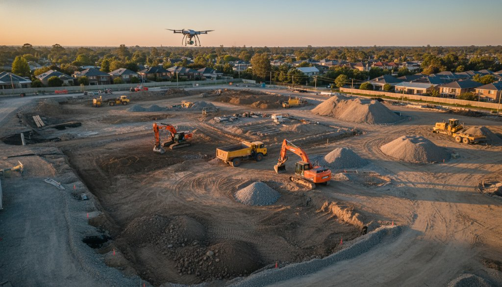
For any large-scale infrastructure project, earthworks are truly the bedrock upon which everything else is built. Achieving optimal results and adhering to strict timelines and budgets hinges on accurate earthworks monitoring. Our advanced drone technology delivers comprehensive topographic mapping, generating highly detailed digital terrain models (DTMs) and digital surface models (DSMs). This allows project managers to perform precise volumetric analysis, calculating cut-and-fill quantities with unmatched accuracy. Imagine tracking every cubic metre of soil moved near the leafy streets or bustling commercial hubs of Cheltenham – our aerial surveys make this possible, significantly reducing costly errors and speeding up progress. The actionable data collected informs every decision, from initial ground preparation to final grading, ensuring every contour aligns perfectly with design specifications and environmental considerations.
Beyond Visuals: 3D BIM Integration and Photogrammetry
While stunning aerial visuals capture attention, the true power of drone technology for infrastructure lies in the robust, actionable data it collects. SkyShots utilises advanced photogrammetry techniques to convert thousands of overlapping high-resolution images into incredibly precise 3D models. This rich spatial data is then seamlessly integrated into Building Information Modelling (BIM) workflows, facilitating sophisticated 3D BIM integration. This isn’t merely about creating pretty pictures; it’s about providing engineers, architects, and project managers with a digital twin of the site, enabling proactive problem-solving, enhanced collaboration, and real-time progress tracking across all project stakeholders. From the earliest planning stages to ongoing construction, our aerial solutions offer critical insights, ensuring design accuracy, compliance, and optimal resource allocation throughout these multi-billion-dollar infrastructure megaprojects.
Operating in an area like Cheltenham, with its intricate blend of suburban living, local businesses, and proximity to natural features like the nearby Port Phillip Bay coastline, adds another layer of complexity. Our detailed aerial surveys provide crucial environmental insights, helping project teams to minimise disruption to the local community and delicate ecosystems. Whether monitoring the exact progress of new rail corridors or assessing the impact of new road networks, SkyShots delivers the high-resolution, georeferenced data needed for informed, responsible decisions, ensuring that development is both efficient and sustainable.
In the dynamic and high-stakes landscape of modern infrastructure development, staying ahead means embracing innovative technology and partnering with experts. For projects in Cheltenham and across Australia, SkyShots is your trusted partner for precision aerial data solutions. Our unparalleled expertise in Cheltenham SRL East Aerial Earthworks Monitoring provides the detailed topographic mapping, comprehensive earthworks monitoring, accurate volumetric analysis, and seamless 3D BIM integration necessary to drive your project to resounding success. Elevate your project’s potential and ensure unparalleled accuracy with SkyShots. Contact us today to learn how our advanced drone solutions can support your next major infrastructure endeavour, delivering clarity and control from above.
Leave a Reply