In the bustling heart of Bayside Melbourne, where the urban landscape meets the serenity of Port Phillip Bay, Cheltenham is rapidly transforming. With an unprecedented wave of development and the inception of significant state-wide initiatives, the demand for cutting-edge data capture is soaring. This is precisely where Precision Aerial Surveying Cheltenham Infrastructure Megaprojects comes into its own, offering unparalleled insights and efficiencies for large-scale developments and crucial urban planning. SkyShots is at the forefront, providing sophisticated drone solutions tailored to the unique needs of this dynamic region.
Precision Aerial Surveying for Cheltenham’s Infrastructure Megaprojects
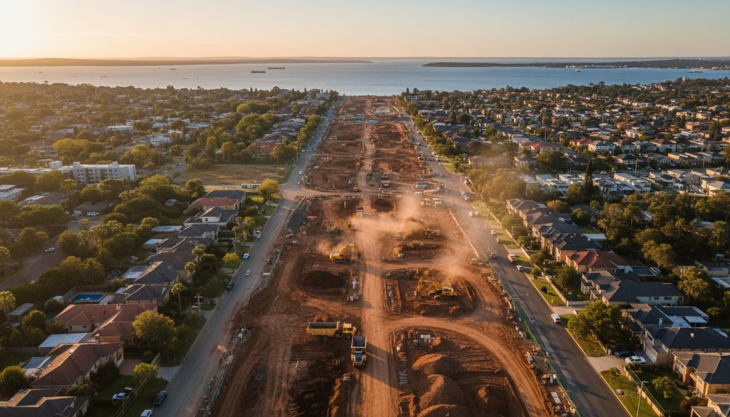
Cheltenham, with its strategic location along major transport corridors like the Nepean Highway and proximity to key industrial zones, is poised to play a crucial role in Victoria’s future. The impact of multi-billion-dollar infrastructure megaprojects, such as the Suburban Rail Loop (SRL) East, SRL Airport, and the expansive North East Link, traversing these specific established corridors, cannot be overstated. These projects demand meticulous planning, continuous monitoring, and precise data—exactly what commercial aerial photography delivers.
Traditional surveying methods often prove time-consuming, costly, and can pose significant safety risks on large, active construction sites. Drone technology revolutionises this, allowing for rapid deployment, comprehensive data collection, and access to challenging terrains, all while enhancing site safety and operational efficiency. Imagine monitoring a vast earthworks project near the Heatherton Road intersection or assessing progress around the bustling Westfield Southland area with unprecedented detail and speed.
Advanced Aerial Applications for Complex Projects
At SkyShots, we leverage state-of-the-art drone technology to provide a suite of advanced aerial surveying services critical for today’s infrastructure challenges:
- Topographic Mapping: Generating highly accurate 2D and 3D maps and digital terrain models (DTMs) essential for initial site assessments and detailed design planning.
- Earthworks Monitoring: Tracking changes in excavation and fill volumes over time, ensuring projects stay on schedule and within budget. Our precision allows for frequent updates that traditional methods can’t match.
- Volumetric Analysis: Calculating precise quantities of stockpiles, cut, and fill, which is invaluable for resource management and progress reporting. This ensures accurate billing and material management.
- 3D BIM Integration: Creating detailed 3D models that can be seamlessly integrated into Building Information Modelling (BIM) workflows, enhancing collaboration and reducing errors from design to construction.
- Photogrammetry: Utilising advanced photogrammetric techniques to create highly detailed, geo-referenced orthomosaics and 3D point clouds, offering an unparalleled visual and analytical record of your site.
These capabilities are particularly vital for the corridors of the Suburban Rail Loop, where precise measurements and ongoing monitoring of ground movement, material quantities, and construction progress are paramount. Our drones capture data that directly supports engineers, project managers, and environmental consultants in making informed decisions, mitigating risks, and ensuring project integrity from conception to completion.
Why Choose SkyShots for Your Cheltenham Project?
As a leading Australian aerial and drone photography business, SkyShots brings local expertise combined with global-standard technology. We understand the unique environmental and regulatory landscape of Cheltenham and greater Victoria. Our CASA-certified pilots are experts in safe and efficient drone operations, ensuring that your project receives the highest quality data with minimal disruption.
Whether you’re involved in commercial property development, land surveying, or contributing to significant public works, our commercial aerial photography services provide the clarity and precision you need. We’re not just taking pictures; we’re capturing actionable intelligence that drives progress and safeguards investments.
The future of Cheltenham’s infrastructure is being built today, and accurate, timely data is its foundation. Partner with SkyShots to elevate your next project. Explore our comprehensive drone surveying solutions and discover how we can help you achieve your project goals with unmatched precision and efficiency.
Ready to see your Cheltenham project from a new perspective? Contact SkyShots today for a consultation and let us help you unlock the full potential of aerial data.
Leave a Reply