Cheltenham, a vibrant suburb nestled in Melbourne’s southeast, is on the cusp of significant transformation. With its desirable blend of coastal proximity, excellent amenities, and a strong community spirit, it’s no wonder property development here is booming. However, navigating this evolving landscape, especially with the monumental Suburban Rail Loop (SRL) East project on the horizon, demands unparalleled precision and insight. This is where Cheltenham Property Development Aerial Mapping for SRL East Volumetric Analysis becomes an indispensable tool for developers, project managers, and investors.
Navigating Cheltenham’s Development Landscape with Precision
The Australian government’s commitment to multi-billion-dollar infrastructure megaprojects like the Suburban Rail Loop (SRL) East, SRL Airport, and the North East Link, is set to redefine established corridors across Victoria. Specifically, the SRL East, with its proposed stations and intricate network, will significantly influence property values and development potential in areas like Cheltenham. For any developer looking to invest in or expand within this dynamic environment, understanding the exact contours, existing structures, and potential future impacts is critical. Traditional surveying methods, while valuable, often cannot keep pace with the scale and complexity of these transformative projects. Aerial insights, however, offer a comprehensive and efficient solution, providing a bird’s-eye view of your assets and the surrounding landscape.
The Power of Aerial Mapping for SRL-Affected Zones
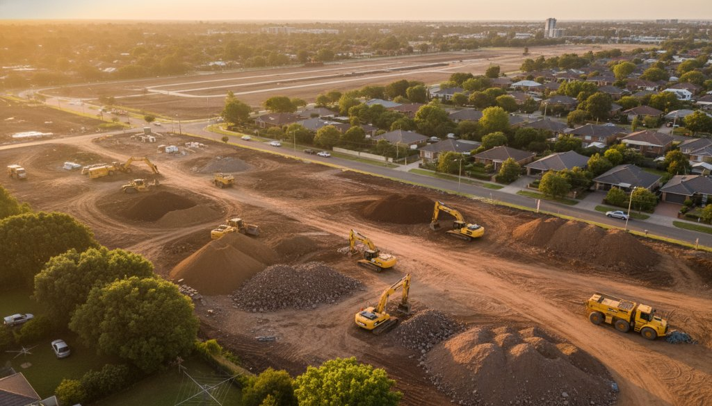
At SkyShots, we leverage state-of-the-art drone technology to provide meticulous data crucial for modern property development in Cheltenham. Our services extend far beyond simple photography, offering robust solutions for even the most intricate projects. Imagine gaining precise topographic mapping of your site, allowing for accurate planning and design. Our expertise in earthworks monitoring ensures that excavation and construction progress are tracked with unparalleled accuracy, minimising costly errors and delays. We specialise in volumetric analysis, providing exact measurements of material stockpiles and cut-and-fill operations – an invaluable asset for budget management and project efficiency. Furthermore, our capability for 3D BIM integration transforms raw data into actionable models, streamlining collaboration and decision-making across all project stakeholders. All this is underpinned by advanced photogrammetry, creating highly detailed 3D models and maps that capture every nuance of your Cheltenham development.
These advanced aerial solutions are not just about pretty pictures; they’re about providing critical data for informed decisions. For more details on how our cutting-edge technology can benefit your project, explore our mapping and surveying services. We understand the specific challenges and opportunities presented by major infrastructure developments and offer tailored solutions to ensure your project’s success, from initial planning to final execution. Our work also seamlessly integrates with large-scale construction progress monitoring, ensuring a holistic approach to your development.
SkyShots: Your Partner in Cheltenham’s Future
As a local Australian aerial photography business, SkyShots has an intimate understanding of the Cheltenham landscape, from its leafy streets near the Kingston Heath Golf Club to its bustling retail hubs and proximity to Port Phillip Bay. We appreciate the unique character of this suburb and how it’s evolving. The Suburban Rail Loop East project presents both challenges and unparalleled opportunities for growth, and we are here to help you capitalise on them. By partnering with SkyShots, you gain a dedicated team committed to delivering precise, high-resolution aerial data tailored to your specific needs. We pride ourselves on our professionalism, efficiency, and ability to provide the comprehensive insights required to navigate complex development landscapes, especially those influenced by major government initiatives. Staying updated on these projects is crucial, and official resources like the Suburban Rail Loop East project page offer valuable information. For local planning and community information, the City of Kingston website is also an excellent resource.
Don’t leave the success of your Cheltenham property development to chance. Empower your decisions with SkyShots’ expert aerial mapping and analysis. Contact us today to discover how our tailored solutions can provide the clarity and precision you need to thrive in this exciting era of growth and transformation.
Leave a Reply